North Canterbury

To Mid Canterbury To Mid Canterbury   - | -   A New Zealand GenWeb Project.   - | - To NZGenWeb Canterbury To Canterbury

Nth CBY Map
Page 2:- Patsy Mac tells us about her PHOTOS.
Page 3 (I need more material for this.)
North Canterbury Places
Conway RiverWaiau RiverWaiau
CheviotRotherhamHamner Springs
CulverdenHurunui RiverMotunau
ScargillWaikariWaipara
Waipara RiverAmberleyBroomfield
LeithfieldWaikukuLoburn
Waipara RiverAmberleyBroomfield
BalcairnSeftonAshley River
RangioraWoodendCust
FernsideSwannanoaOxford
KaiapoiWaimakariri RiverHawarden
DommettGore BayGreta Valley
Ohoka Kowai Saltwater Creek

North Canterbury is sparsely populated, (in the north); consisting of dry, rolling to hilly land and large farming blocks, (sheep runs). CHEVIOT, the largest and sole town in the large northern region of the province is named after the Cheviot Hills on the Scottish border with England and from whence 'Cheviot Sheep' were imported in 1840s. Inland from Cheviot is WAIAU.
The southern region of North Canterbury is somewhat more populous. Bounded by towns like Oxford to the West and Amberly on the East and southwards from the Ahley River to the Waimakariri River, this area moves from sheep to grain & mixed farming.
These days, there is a lot of development of small holdings - 10 acre 'life-style' blocks. These, ususally owned by workers commuting to Christchurch city, Rangiora or Kaiapoi, often indulge in some less traditional land uses. Grapes for wine, Deer, Lamas & Ostriches are likely to be found, as well as Olives. Forestry is a major industry due to the dry, stoney land bordering the middle area of the Waimakariri River on ine the more hilly & mountainous western areas of Lees valley. Specific plantations are Eyrewell, Ashley & Balmoral forests.

SEFTON - KOWAI - BALCAIRN

Little towns with a proud rural heritage.
Since 1875, The Kowai District Council offices in Balcairn has been a centre for local body activities. Presently, May 1999, that building is the home of the Kowai - Sefton Archives Group which restored the site in 1995.
Since it is more of archives than museum, it houses many of the local school and church records of the area. The building, with a Historic Places Trust Grade 2 classification, was built in 1922 as a Peace Memorial.   In the foyer are two impressive marble War Memorial Plaques.
Kowai Archives has local record information that includes the Amberley Historical Society, and extending from the Ashley to Waipara rivers.

      Contact:-
 Chief Archivist
 Kowai Archives          (Use this name on cheques.)
 c/- Terry Green 
 21 Amors Road, 
 RD 2, 
 Rangiora 7472.        Tel. 03 312 9852

Email address: kowai.archives at gmail.com.
The Archives volunteers are happy to advise you if they hold information on your research topic.
Also, please say that you found the contact information on this NZGenWeb page.

The Hurunui District Council now administers this region.
  • I will let the Hurunui District Council tell you about their region.
    You can write to them about cemetery records. Click on Services then Cemeteries for a friendly description and offer of data from thier records - which can also be found at:- Hurunui District Cemeteries.

    KAIAPOI MUSEUM

    Kaiapoi Museum is run by the Kaiapoi District Historical Society Inc. 145 Williams Street Kaiapoi.
    Collection area: Kaiapoi town and areas including Kaiaraki and Pines Beaches, Woodend, Tuahiwi, Flaxton, Ohoka, Clarkville, Eyreton and Swannanoa.
    Holdings: Records of societies, sports clubs, lodges and organisations, cemetery records, scrapbooks, photographs, maps, oral history recordings, clothing plus displays of everyday items from years gone by.

    KAIAPOI Historical Records Society Inc.
    145 Williams Street
    Kaiapoi
    Canterbury.

    Phone:- (+64)-3-327.7151 during Museum hours.
    Open Thursday & Sundays
    2:00 - 4:00pm

    Contact:-
    Dale Brown,
    Post to:- P.O. Box 341, Kaiapoi.
    Phone (+64)-3-327.7705 outside Museum hours.


    The building that is the
    Kaiapoi Historical Records Museum.
    First use as Court House, 1890.
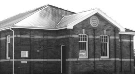
    Kaiapoi Museum
    The Old Court House building which replaced the previous one built in 1866 which was located next door on the corner of Charles and Cookson Streets (now Williams Street).
    The Court House was closedin 1951.


    From Peter ARMSTRONG we have a link to an extremely good site describing KAIAPOHIA in relation to his ACKER family. Peter has brought out the history of the Pa rather well, complete with maps and photos.Well worth a visit, even for those with only a passing interest in era of 1830's Canterbury. {BEP}

    OXFORD MUSEUM
    75 Main Street	(+64)-3-312.4533
    Oxford		Open Sundays
    Canterbury.	2:00 - 4:00pm
    

    CUST MUSEUM
    Cust & Districts Historical Records Society Inc.
    President:- B. KINGSBURY   (+64)-3-312.5839
    Sectrary :- Mrs P. PESTER     (+64)-3-312.5720
    P.O. Box 110        
    Cust             .        Open Sundays
    Canterbury.         2:00 - 4:00pm
    We will open at other hours for a small fee.

    Bus Tours:- A guided tour of the area can be arranged.
    Afternoon tea or Lunch can also be arranged.

    The collection pertains to
    Cust, West Eyreton, Springbank, Summerhill & Horrelville districts.
    Archives, Artifacts and objects.
    The building that is the
    Cust & Districts Historical Records Museum.
    Established, 1988.
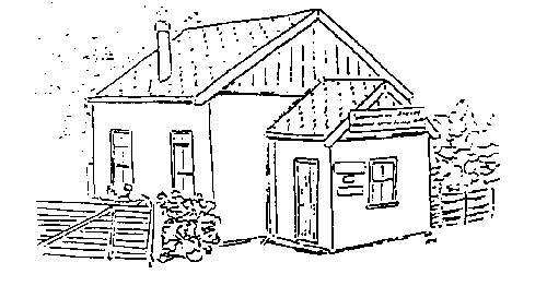
    Cust Museum
    On Main Road Between Rangiora and Oxford.


    RANGIORA MUSEUM
    37 Good Street	(+64)-3-313.7592
    Rangiora	Open Sundays
    Canterbury.	1:30 - 4:00pm
    

    WAIMAKARIRI BRANCH of NZSG
    Meeting on third Tuesday of each month at
    Rangiora Brass Band Rooms
    Northbrook Studios
    Northbrook Road
    RANGIORA
    7.30 p.m. start
    Contact:	Convenor is	Jack Haworth	- (03) 313 9917 	
    		Secretary is	Alan George	- (03) 313 3490 	
    
    20-04-2007
    

    Saltwater Creek School Register

    one and two from 1 December 1881 to 5 February 1951. 422 pupils and a list of teachers from 1865 to 1932 a total of 42.

    Saltwater Creek is approx 20 miles north of Christchurch and was originally known as Northport and the port was officially opened in 1859. The port had a chequered career with a disastrous flood in 1868 and then in 1874 the Government decided to build the railway to the west of the port through what is now Sefton and gradually the township declined and by 1878 its population was only 46. There was a flaxmill built locally but the port was mainly used by the local runholders to move their wool clip and stock. Those living at the Creek were either farmers, labourers or mill workers.
    Patsy McMillan will lookup the above regisiters if you think your folks lived & worked in this area during time frame shown.       Patsy's Home Page.
    Patsy has added some PHOTO information on this NZGenWeb project page.


    Should you find anything that you consider, incorrect, inappropriate, require adding, would like to see, like to contribute, PLEASE, do eMail Webmaster (below).
    I am particularly interested in obtaining research resource information from North & Mid Canterbury areas, regions, towns, & localities outside Christchurch city. YOU can be effective in putting your locality on the Genealogical Internet!
    If you are a member of NZSG, would you please mind adding your number to correspondence so I might gauge extent of interest for the society.
    Note:- I am not available to perform research for you, although, via email, I might be able to advise on opportunities & places to go.

    ===
    To PYCROFT Page To PYCROFT Index Page - | - To Mid Canterbury To Mid Canterbury - | - To Canterbury To NZGenWeb Canterbury
    Last updated on 20-04-2007 -       Previous change April 2006.
    Copyright © 30-05-1999 - - B. E. PYCROFT. (Webmaster), Christchurch, New Zealand. NZSG #8530